
Published Year: 2023
U.S. Geospatial Imagery Analytics Market - A Regional Analysis: Focus on Application and Solution -
The U.S. geospatial imagery analytics market is estimated to reach $8.38 billion in 2033 from...
Focus on Application, Solution, and Country - Analysis and Forecast 2022-2032
Delivery Time: 1-5 Working Days
Get ISO Certified Research, Customization, Data Extraction, and Value-Added Services with All BIS Research Reports
BIS Research provides a comprehensive report library with unlimited access to data, insights, and market intelligence through Subscription.
Get Subscription Know MoreGlobal Geospatial Imagery Analytics Market Overview
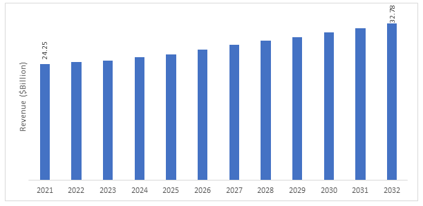
The global geospatial imagery analytics market is estimated to reach $32.78 billion in 2032 from $24.25 billion in 2021, at a growth rate of 2.90% during the forecast period 2022-2032. Geospatial imagery analytics companies have witnessed a significant demand for applications such as disaster management, agriculture, cartography, and natural resources survey.
Market Lifecycle Stage
Geospatial data analytics has a long history since it started in the 1960s and was first used by Canada to use geographic information systems (GIS) to create a map-based inventory of natural resources. The first automated process of collecting geospatial data was developed by collaborating with IBM programmers for Canadian territory.
Today, the geospatial analytics market has changed significantly, and geospatial analytics has diverse applications. It is used for data collection, understanding the relationship between multiple data sources to analyze the trend, and accurate predictions. Geospatial analytics has spread over various applications such as weather monitoring, surveillance, urban planning, and disaster management. Geospatial imagery analytics have depended more on imagery from multiple sources, such as satellites, aerial vehicles, and aircraft.
Furthermore, the rise in the deployment of small satellites for Earth observation in low Earth orbit (LEO) has generated demand in the geospatial analytics market. The small satellites have made the imagery data more accessible and cost-effective. So, the users are dealing with a large influx of data, raising the demand for geospatial analytics. For instance, in January 2022, Planet Labs PBC, an Earth-imaging company, launched 44 SuperDove satellites onboard Space X’s Falcon 9 rocket.
Global Geospatial Imagery Analytics Market, $Million, 2021-2032
Impact
• The increase in adoption of artificial intelligence (AI) and machine learning (ML) for geospatial data analytics platforms has placed a high demand for the geospatial imagery market during the forecast period.
• Furthermore, rising in small-satellite deployment provides high-resolution, low-cost, and quick imagery delivery.
Market Segmentation:
Segmentation 1: by Application
• Aviation
• Maritime
• Agriculture and Forestry
• Sustainability and Natural Resource Monitoring
• Oil and Gas
• Energy
• Logistics/Shipping
• Defense
• Civil Government
• Construction and Infrastructure Development
• Healthcare
• Surveying/Cartography
• Disaster Management
• Business Intelligence
• Finance and Insurance
• Mining
Based on application, the global geospatial imagery analytics market is expected to be dominated by the construction and infrastructure development segment during the forecast period. This is due to increased demand for geospatial technologies in applications such as 3D modeling, digital twin, and urbanization of cities.
Segmentation 2: by Solution
• Data Acquisition
• Data Processing
• Analytics
• Integrated Delivery Platform
Based on Solution, the global geospatial imagery analytics market is expected to be dominated by the analytics segment during the forecast period. This is due to the increasing size of data sets from multiple sources requiring more efficient analytics to understand the data.
Segmentation 3: by Region
• North America - U.S., Canada
• Europe - France, Germany, Russia, U.K., and Rest-of-Europe
• Asia-Pacific - China, India, Japan, and Rest-of-Asia-Pacific
• Rest-of-the-World - the Middle East and Africa and Latin America
Europe accounted for the highest share of 29.88% in the global geospatial imagery analytics market by value in 2021, owing to a significant number of companies based in the region.
Recent Developments in Global Geospatial Imagery Analytics Market
• In September 2022, Satellogic signed a three-year agreement with the Government of Albania to build a dedicated constellation. The company's high-quality imagery will resolve Albania's significant issues, such as illegal construction, illegal crops, traffic management, wildlife monitoring, and border security.
• In September 2022, TomTom N.V. signed a partnership with Hyundai Motor Group (HMG) to provide its maps and real-time traffic data. HMG will use TomTom’s high-quality maps for its entire Europe vehicle lineup.
• In August 2022, Esri signed a renewed partnership with the National Technical Information Service (NTIS) of the US Department of Commerce. As per this partnership, NTIS would be able to access geospatial data in order to analyze and support government agencies in enhanced decision-making capabilities.
• In August 2022, BlackSky Technology Inc. received a contract from NASA to evaluate the quality of the company’s imaging data services for the Commercial Smallsat Data Acquisition (CSDA) Program. The company would provide its dawn-to-dusk imagery data for NASA’s Earth science mission.
Demand - Drivers and Limitations
Following are the drivers for the global geospatial imagery analytics market:
• Increasing Need for Data-Driven Decision Making
• Increasing Threat Perception Related to Natural Disasters (Impact of Climate Change)
Following are the challenges for the global geospatial imagery analytics market:
• Presence of Legacy Systems Delaying Integration with Next-Gen Solutions
• Lack of Mutual Sharing of Data Across Regional Stakeholders
Following are the opportunities for the global geospatial imagery analytics market:
• Cheaper Geospatial Solutions for Small and Medium Enterprises
Analyst Perspective
According to Arunkumar Sampathkumar, Principal Analyst, BIS Research, "The rising demand for geospatial imagery analytical services across multiple industries such as environmental monitoring, agriculture, energy, defense, business intelligence, finance, construction and infrastructure, and oil and gas will drive business opportunities for the key players in the geospatial imagery analytics market. Hence, the market is expected to grow significantly during the forecast period 2022-2032."
Focus on Application, Solution, and Country - Analysis and Forecast 2022-2032
The key technological trends in the global geospatial imagery analytics market include imaging capabilities, artificial intelligence (AI)/machine learning (ML), 3D modeling/digital twin, LiDAR technology, and small satellites.
The global geospatial imagery analytics market has seen major development by key players operating in the market, such as business expansion activities, contracts, partnerships, collaborations, mergers and acquisitions, and joint ventures. According to BIS Research analysis, the majority of the companies preferred collaborations, contracts, and agreements as a strategy to further increase their growth in the global geospatial imagery analytics market. Companies such as BlackSky Technologies, Esri, KSAT, L3Harris Technologies, Inc., and Maxar Technologies Inc. have adopted contract, collaboration, and agreement strategies.
New satellite imagery providers can enhance their satellite constellation to provide multi-sensor imagery data, such as synthetic aperture radar (SAR) and optical imagery. Furthermore, the analytics providers can work on enhancing AI/ML use in their integrated software platforms. Also, new market participants can work on providing real-time monitoring capabilities, which will be critical for sustainable growth opportunities.
The following can be seen as some of the USPs of the report:
· A dedicated section focusing on the futuristic trends adopted by the key players operating in the global geospatial imagery analytics market
· A dedicated section on growth opportunities and recommendations
· A qualitative and quantitative analysis of the geospatial imagery market based on the application at the regional and country-level granularity by application segments
· More than 800 companies are considered for market estimation.
Companies that provide geospatial imagery services, and also small and medium enterprises, governments, and different industry users, should buy this report.
The U.S. geospatial imagery analytics market is estimated to reach $8.38 billion in 2033 from...

The global satellite Earth observation data and value-added services market is expected to...